An Affordable Housing Community Captures and Refines ArcGIS® Data with AR
Augmented reality technology helps a commercial and residential mobile home park in El Jebel, Colorado visualize and refine its GIS data, saving time and improving safety outcomes.
Utility Location with AR Gives Positive Results
Improved safety outcomes, more accurate GIS data, and time savings are all positive results Crawford Properties, LLC, a commercial and residential mobile home park, is seeing after adopting the Argis Lens as part of its utility location process. Located in El Jebel, Colorado, Crawford Properties consists of approximately 289 mobile home lots, 15 apartments and rental homes, 29 commercial units, and an assortment of tenants renting open space for storage. They are a Tier One member of Colorado 811 with a total team of six field crew members, three of which are certified locators. The locator crew handles approximately 10 locates a month.
AR Facilitates Knowledge Transfer
Even before Colorado’s recent Subsurface Utility Engineering (SUE) legislation was passed, Crawford’s property manager and owner, Prentice Hubbell, began to look at augmented reality as a possible solution for Crawford’s operations needs. For almost 60 years, foreman Noel Crawford gathered an almost encyclopedic knowledge of Crawford Properties’ 5.4 square miles of underground assets-- water, sewer, gas, and electrical infrastructure that supports life and business for El Jebel’s 1600 residents.
The sewer infrastructure consists of plastic piping with no tracer wires, so it wasn’t a simple process for others to access what Noel had mentally catalogued throughout his years of work. With Noel’s well-earned retirement on the horizon, Hubbell began to consider the Argis Lens, a mobile app that translates ArcGIS feature services into augmented reality in real time, as the solution for cataloguing and communicating the valuable information that was currently only accessible through Noel.
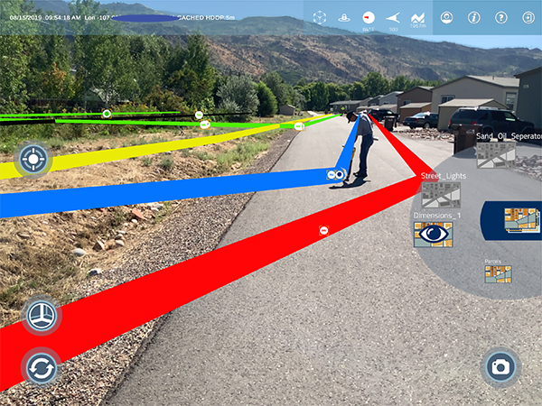
AR Makes it Easy
The Argis Lens was attractive to Hubbell because he knew that its integration with ArcGIS would allow his crew to create a database of this geolocational information, enabling any of them to access it quickly and confidently. His newer generation of technologically-aware field crew members were comfortable with the intuitive layout of the Lens app, so implementation was easy. Communication was now streamlined. Immediately, in one if its first time using the Lens, the team noticed it was much easier to perform sprinkler system maintenance on the community’s baseball field. Spatial confusion was quickly becoming a thing of the past.
Ticketing Management with Augmented Reality
Crawford Properties’ next step is to complete the rollout of Argis Solutions’ augmented reality ticketing management system, ARTMS, to streamline the process Crawford uses to show positive response required of all Tier One members for Colorado 811 transactions in their area. The system already ingests Colorado 811 marking requests and allows users to give a positive response directly from the field within the application. Tracking workers, ticket assignments, and situational awareness in AR for the crew member working in the area of interest associated with the ticket are additional benefits of using the system.
The AR Workflow in Utility Location
What does a workflow for Crawford Properties look like for common issues like addressing a water line leak? First, a tenant calls in a leak, and Colorado 811 locates gas and electric lines. Then the Crawford team makes their own marks to denote Crawford’s infrastructure, and the crew starts digging. Once assets are uncovered, the Lens is used to create a photographic record. After repairs are made, the team updates the assets’ geolocational information so Crawford can benefit from a more accurate geolocational record in the future. Hubbell’s advice on implementing the Argis Lens into a workflow: “Just start. Start. Start with your street signs. Then add your roads. And eventually you will have good GIS data. Add notes in your attribute area for the field team so they know. Add ‘just a guess’ if you aren’t sure. At least it gives them something.” Hubbell remains pleased by the results Crawford’s field crews have been able to achieve with the Argis Lens in their virtual toolbelts.